
Maps | ET&WNC Railroad
Appalachian-Railroads Navigation: Home Page
- Railroad Overview | Route Comparison
- Legacy: B&O | C&O | Clinchfield | L&N | NC&StL | N&W | PRR | SOU | VGN
- Early: 3Cs | ET&WNC | LC&C | More
- Related: ACL | SAL | SCL
- Northern: DL&W | Erie | Erie Lack | NYC | P&LE | Reading | Western MD | W&LE
- Short: G Mid | K&T | Tallulah | More
- Consolidation: Chessie | Family | Penn Cen | Conrail | Seaboard
- Today: CSX | Norfolk Southern | Amtrak
- Abandoned | Railfan Guides | Rail Trails
- Railroad Cities/Towns | Mtn Gaps/Passes
- Resources: Authors | Books | Museums | Organizations | Links
- Model Railroads: 3Cs | ET&WNC
- Website: Site Map | Editor
- Clinchfield.org | Southern-Railroads.org

Page Contents
East Tennessee & Western North Carolina Railroad Maps
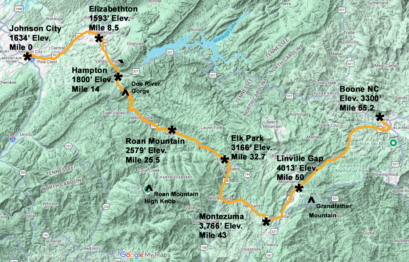
The East Tennessee and Western North Carolina Railroad (ET&WNC) was actually two railroads operated as a single line. The original ET&WNC ran from Johnson City TN to Cranberry NC. The Linville River Railroad connected with the ET&WNC at Cranberry and extended to Boone NC.
The distance from Johnson City to Boone was slightly over 65 miles. From Johnson City with an elevation of 1634′ the ET&WNC climbed almost 2600′ to Linville Gap at 4013′. The narrow gauge of the ET&WNC was chosen due to the need for tight curves and steep grades to navigate the mountains.
The well-know geographic features along the route were the Doe River Gorge, Roan Mountain, and Grandfather Mountain.
Below are two types of maps, the first being a present day map locating the route of the railroad, much of which survives as a road or a trail. You can view the map in detail by clicking on the Google Interactive Map link. You can also view and download the static map that includes key points, elevations, and mileposts. Further down the page are historic maps.
Historic ET&WNC Route, Link for Interactive Map
Click on this link for a Google Interactive Map where you can view in much greater detail and down to street level.

ET&WNC Map – 1922

ET&WNC Map and Timetable – 1922

Map and Timetable from Johnson’s Depot at StateOfFranklin.net. Click here for their ET&WNC collection.
ET&WNC Sources & Resources
The following are excellent resources for those of you wanting to explore and learn more about the ET&WNC Railroad. These sources of information also serve as reference and historical materials for Appalachian-Railroads.org. Much of the content on the website is verified across multiple sources.
- Archives:
- Associations:
- ET&WNC Railroad Historical Society and their Facebook Page
- George L. Carter Railroad Historical Society (Johnson City Railroad Experience)
- Personal Maps & Memorabilia: Documents, maps, timetables, and track charts
- Books:
- Ferrell: ‘Tweetsie Country’
- Graybeal: ‘The Railroads of Johnson City’
- Graybeal: ‘Along the ET&WNC’ Volumes 1-6
- Poole: ‘History of Railroading in Western North Carolina’
- Scheer & Black: ‘Tweetsie: The Blue Ridge Steamwinder’
- Sulzer: ‘Ghost Railroads of Tennessee’
- Newspaper Articles: Newspapers.com
- Magazines/Online: ‘Trains‘, ‘Classic Trains‘
- Websites:
- Carolana.com
- CarterCountyHistory.com
- StateOfFranklin.net which hosts Johnson’s Depot
- SteamLocomotive.com