
Johnson City Southern and South & Western Railfan Guide
- Site Navigation: Home Page
- Railroad Overview | Route Comparison
- Legacy: B&O | C&O | Clinchfield | L&N | NC&StL | N&W | PRR | SOU | VGN
- Early Lines: 3Cs | ET&WNC | LC&C | More
- Related: ACL | SAL | SCL
- Northern: DL&W | Erie | Erie Lack | NYC | P&LE | Reading | Western MD | W&LE
- Short Lines: G Mid | K&T | Tallulah | More
- Consolidation: Chessie | Family | Penn Cen | Conrail | Seaboard
- Today: CSX | Norfolk Southern | Amtrak
- Abandoned | Railfan Guides | Rail Trails
- Railroad Cities/Towns | Mtn Gaps/Passes
- Resources: Authors | Books | Museums | Organizations | Links
- Model Railroads: 3Cs | ET&WNC
- 3Cs: Site Map | Editor
- Clinchfield.org | Southern-Railroads.org
Page Contents
Railfan Guide for the Johnson City Southern Railway and South & Western Railways
Researched and chronicled by Scott Jessee and Sandhi Kozsuch
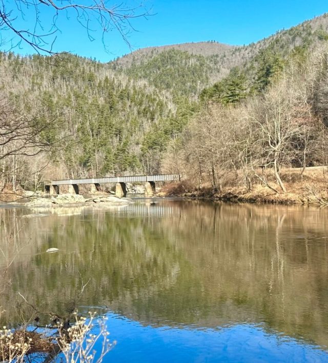
Photo: A view from the abandoned roadbeds of the Johnson City Southern and South & Western Railway looking across the Toe River toward the current CSX/Clinchfield bridge just north of Poplar NC
From 1905 to 1907, the Southern Railway did its best to thwart the efforts of the South & Western Railway (S&W/Clinchfield) to build a line south through the NolichuckyToe River Gorge and across the Blue Ridge Mountains. The Southern’s effort to build a duplicate line, whether half-hearted or a serious attempt, was named the Johnson City Southern Railway (JCS). Both the S&W and the JCS would have been a more direct route and easier climb from the coal fields of Virginia to the Atlantic ports than Southern’s existing line through Asheville and across Saluda Mountain. Scott Jessee, Mike Tilley, and I made several trips, searching for, and finding quite a bit of the JCS roadbed. For those of you who are interested in the fascinating story and the surviving roadbed, the following history and the information in the JCS Railfan Guide will give you a basic understanding of what was, and what remains.
Carter’s Two Front Railroad War
George L. Carter, the founder and visionary leader of what would become the Clinchfield Railroad was having to fight a two front railroad war in the early 1900s against two entrenched competitors. In the north he was fighting the Chesapeake and Ohio Railway for control of the Russell Fork River through the Breaks on the KY/VA border, the Grand Canyon of the South. In the south, it was a fight with the Southern Railway for control of the Nolichucky/Toe River gorge on the TN/NC border. Both of these challenging rivers and gorges were key to building a direct link from Elkhorn City KY to Spartanburg SC, a much needed rail corridor across the middle of the Appalachian Mountains that would become a very busy and profitable coal and manifest freight rail line. The C&O and the Southern also knew this, so it became a tussle between ‘David (Carter) and Two Goliaths.’
South & Western’s Two Alignments
Photo: Clinchfield/CSX in foreground, S&W’s .5% and JCS across the river

George L. Carter, the S&W’s visionary leader was a shrewd businessman. Not only did the S&W purchase an old existing railroad (OR&C) along one side of the river, but they also purchased segments of land on the opposite side of the river for a proposed .5% grade alignment that would make if much easier for heavy coal trains to climb to the top of the Blue Ridge at Altapass NC. Seeing this threat to their existing business, the Southern Railway, under the name of Johnson City Southern, jumped into action. Thus, on the following surveys and maps, you will see three alignments: 1) The S&W’s existing railroad purchased from the OR&C 2) The S&W’s proposed ,5% grade alignment designed with exemplary engineering standards, and 3) The Southern’s JCS proposed alignment.
Surveys, Court Battles, and Some Construction
The Southern Railway expended a substantial sum on surveys, legal proceedings, and some construction. Today, you can see the Johnson City Southern graded roadbed
- along the east bank of the Nolichucky/Toe River north of Erwin TN
- on the east bank from Erwin to Poplar
- along the west bank between Poplar and Huntdale NC.
The initial JCS surveys were clear, there was not enough room in portions of the Nolichucky/Toe River Gorge for two railroads. So, the Southern proceeded to try and persuade local officials to condemn the S&W right-of-way that the railroad had purchased just months before. Keep in mind that the S&W owned both the old 3Cs/OR&C roadbed, plus their newly purchased .5% grade alignment. Thus, the S&W had two options up the river owning much of both the east and west banks.
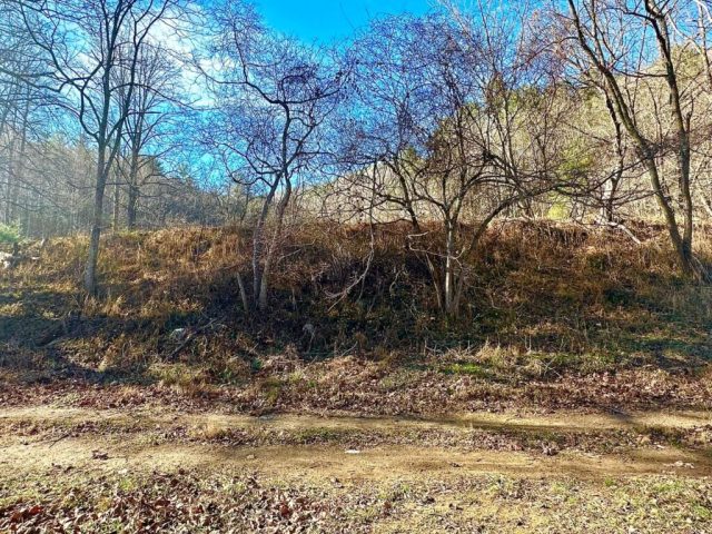
Photo: One of segments where the JCS and S&W roadbeds diverged between Poplar and Huntdale.

Yancey County actually started to oblige the JCS and began condemnation proceedings of the S&W’s right of way, but eventually the Appeals Courts and the North Carolina Supreme Court ruled in favor of the S&W by late 1907. George L. Carter very seldom lost in court, he was smart and relentless and had a great team of lawyers. Additionally, the Southern’s arguments were not well founded, and their dedication to finishing their rail line was suspect.
Click here for more information on the Johnson City Southern Railway.
Poplar to Huntdale
From just north of Poplar southward to Huntdale, the JCS and the S&W were trying to use the same right-of-way. There were only a few short segments where the two lines diverged running side-by-side. For the most part, they were on top of each other. Thus, the JCS was pushing to condemn S&W’s land, and take it for themselves. There were even two opposing construction crews working simultaneously on that western shore of the river, with ensuing verbal fights and skirmishes. Today, you can clearly see the unfinished roadbed along the west bank, and in some places, you can even see two alignments.
Photo: JCS cut adjacent to S&W above on the right.

Photo: A S&W fill above, JCS in foregound
The Poplar Tunnels and the Lone Workman
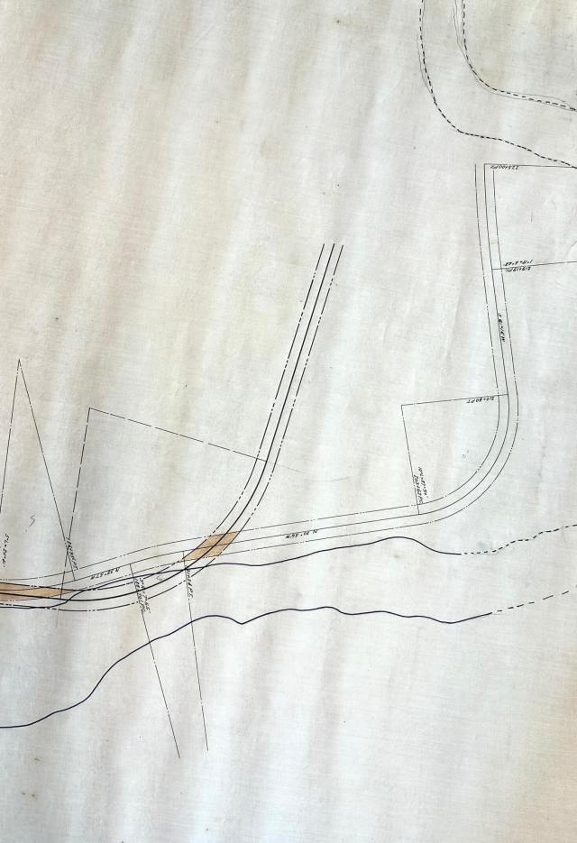
Map: Archives of Appalachia, created for the S&W vs. JCS court proceedings. JCS survey/tunnel to the right, S&W survey/tunnel to the left. Note how the alignments were very similar after exiting the tunnels next to the river. S&W was about 25 feet higher in elevation and had broader curves. The S&W is the darker alignment, the JCS lighter. The brown shading is where the two alignments overlapped, which was most of the time from Poplar to Huntdale. The area of the map is just north of Poplar NC, across the river from the current park/raft launching area.
Railroad lore and press reports throughout the years have told the story about two proposed tunnels in the gorge where the two competing rail lines would have crossed each other inside their respective tunnels. Another story goes that the S&W kept one man posted round the clock at the site of their partially-constructed tunnel entrance, making sure they could say the proposed roadbed was ‘under construction’ while the court battles played out. The Archives of Appalachia has a wealth of railroad documents and maps, including this 30 foot long map showing the two proposed and competing JCS and S&W alignments from Poplar to Huntdale NC.
In Search of the Poplar NC Tunnels
As shown on the map and surveys above, two partially excavated tunnel entrances remain today. While not completed, or very deep, clearly construction had begun. These excavations are the south end of the tunnels. We hope to explore the north ends of the tunnels upon our next visit.


Johnson City Southern Roadbed Guide
Johnson City to Erwin TN
The JCS would have used the Embreeville Branch as its first segment from Johnson City to the Nolichucky River south of the Lamar TN community. To connect the Branch to Erwin, construction of a roadbed was partially completed and can be easily seen along Arnold Road and State Route I-81. Use the interactive map below to locate the roadbed.
Click here for more information on the Embreeville Branch
Erwin TN to Poplar NC
At this time, we have located very few remnants of this segment. We will make additional visits to the area and update this page in the future. If you have information you are willing to share, please contact us.
Poplar to Huntdale NC

The roadbed is clearly visible in this segment. You can view it from across the river at Poplar. Or you can drive south, cross the river at Huntdale, then backtrack north to drive on surviving portions of the roadbed, existing today as Murphytown Road. Use the interactive map below to help you locate the roadbed, and in some areas, both the S&W and the JCS side-by-side.
This portion of the map from the Archives of Appalachia shows how the two alignments of the S&W and JCS were almost the same as they approached Huntdale and the Cane River from the north. The brown shading is where the two surveys overlapped. The lighter of the lines is the JCS.
Photo: JCS roadbed used for a county road.

S&W/Clinchfield Changes Course
Photo: Four units and an empty coal train sits in wait on the Poplar siding patiently waiting their turn for the green light to proceed to Erwin.
Once the legal battles were over, the S&W decided not to use the .5% grade option which had been the target of the JCS, but rather, the S&W upgraded the existing roadbed purchased from the OR&C. One reason might have been the 1907 Financial Panic that affected banks and investors. Even though this alignment was a second choice, it is still superior to most railroads of that era, and has been for many years until the present day.
Interactive Maps for the S&W/Clinchfield and the Johnson City Southern
Alignments from Johnson City TN to the Top of the Blue Ridge

Legend:
- Black-Current CSX/Clinchfield,
- Red-Proposed .5% grade S&W/Clinchfield alignment that was never built
- Orange-Proposed Johnson City Southern Alignment.
Click on this link for a Google Interactive Map. Zoom in and out to see specific areas in more detail.
Note: We are not for sure of the JCS alignment from Huntdale NC to Marion NC, as we have yet to find any surviving surveys. If you aware of any or have additional information, please let us know. However, we do know from press reports that the JCS planned to cross the Blue Ridge at Gillispie Gap.
Photo: JCS roadbed along Arnold Road north of Erwin.

Alignments Around and Through Erwin
Based on S&W surveys and the Archives of Appalachia map, here are the three alignments through Erwin.
Legend: Black-Current CSX/Clinchfield, Red-Proposed .5% grade S&W/Clinchfield Alignment, Orange-Proposed Johnson City Southern Alignment.
Note that the Johnson City Southern would have crossed the S&W/Clinchfield near the south end of the Erwin yard. Also, the proposed .5% grade mainline option for the S&W/Clinchfield would have skirted Erwin to the southeast higher up on a ridge. The proposed line would have crossed the gorge at Unaka Springs on a tall viaduct. This option would have still maintained the yard in Erwin, however, access to it would have been via circuitous connectors to the mainline. Coal trains could have continued their journey south without stopping or slowing down for the yard or Erwin grade crossings.
Click on this link for a Google Interactive Map. Zoom in and out to see specific areas in more detail.

Alignments Through Poplar NC
Based on S&W surveys and the Archives of Appalachia map, here are the three alignments and the two tunnels near Poplar NC.
Legend: Black-Current CSX/Clinchfield, Red-Proposed .5% grade S&W/Clinchfield Alignment, Orange-Proposed Johnson City Southern Alignment.
Click on this link for a Google Interactive Map. Zoom in and out to see specific areas in more detail.
The green and maroon markers denote the two tunnels just to the north of Poplar.

Bob Harvey JCS Photos from the 1980s
Bob Harvey made the same journey into the gorge as we did, but 40 years earlier. Bob was gracious enough to provide us with his slides. Once I can find my slide scanner after a recent move to a new house, I’ll post them here.
For More Information – Sources and Resources
The following are excellent resources for those of you wanting to explore and learn more about the history and operation of the Appalachian Railroads. These sources of information also serve as reference and historical materials for Appalachian-Railroads.org. Much of the collective railroad history data points on this website are verified across multiple sources.
- Personal Maps & Memorabilia: Documents, maps, timetables, and track charts
- Associations, Historical Societies and their Archives
- ACL & SCL Railroads Historical Society
- Baltimore & Ohio Railroad Historical Society
- Chesapeake & Ohio Historical Society
- Carolina Clinchfield Chapter National Railway Historical Society
- ET&WNC Railroad Historical Society and their Facebook Page
- George L. Carter Railroad Historical Society (Johnson City Railroad Experience)
- Louisville & Nashville Railroad Historical Society
- Norfolk & Western Historical Society
- Pennsylvania Railroad Technical and Historical Society
- Southern Railway Historical Association
- Watauga Valley Railroad Historical Society
- Archives of Appalachia: ETSU, Johnson City TN
- Newspaper Articles: Newspapers.com
- Magazines/Online: ‘Trains‘, ‘Classic Trains‘
- Books
- Drury: The Historical Guide to North American Railroads
- Appalachian Region
- Grant: ‘The Louisville, Cincinnati & Charleston Rail Road’
- Graybeal: ‘The Railroads of Johnson City
- Huddleston: ‘Appalachian Crossings – The Pocahontas Roads‘ and ‘Appalachian Conquest‘
- Poole: ‘A History of Railroading in Western North Carolina‘
- Timko and Young: ‘Appalchian Coal Mines and Railroads, Vol. 1, 2, & 3‘
- Roberts: ‘Sand Patch, Clash of the Titans‘
- Yanosey: ‘Tidewater Triangle’
- Atlantic Coast Line Railroad
- Calloway: ‘Atlantic Coast Line, The Diesel Years‘
- Griffin: ‘Atlantic Coast Line, The Standard Railroad of the South‘
- Goolsby: ‘Atlantic Coast Line Passenger Service, The Postwar Years‘
- Baltimore & Ohio Railway
- Jacobs: ‘The History of the Baltimore & Ohio’
- McGuirk: ‘Baltimore & Ohio Railroad in the Potomac Valley‘
- Ori, Salamon and Oroszi: Baltimore & Ohio/Reflections of the Capitol Dome‘ and ‘Baltimore & Ohio/Sunburst Trail to Chicago’
- C&O Railway/Chessie System
- Dixon: ‘Chesapeake & Ohio, Superpower to Diesels‘, Chesapeake & Ohio in the Coalfields, ‘C&O Allegheny Subdivision‘, and ‘Chesapeake & Ohio Railway – A Concise History and Fact Book‘, and ‘The Chessie Era’
- Dorin: ‘The Chesapeake & Ohio Railway’
- Huddleston: ‘Riding the New River Train‘
- Ori – ‘Chessie System‘
- Paton: ‘Allegheny with an A’
- Turner: ‘Chessie’s Road‘
- Clinchfield Railroad
- Beach: ‘The Black Mountain Railway’
- Goforth: ‘Building the Clinchfield‘ and ‘When Steam Ran the Clinchfield‘
- Helm: ‘The Clinchfield Railroad in the Coal Fields‘
- Irwin & Stahl: ‘The Last Empire Builder: The Life of George L. Carter‘
- King: ‘Clinchfield Country‘
- Marsh: ‘Clinchfield in Color‘
- Poteat & Taylor: ‘The CSX Clinchfield Route in the 21st Century‘
- Stevens & Peoples: ‘The Clinchfield No. 1 – Tennessee’s Legendary Steam Engine‘
- Way: ‘The Clinchfield Railroad, the Story of a Trade Route Across the Blue Ridge Mountains‘
- CSX Railroad
- Springirth: ‘CSX Transportation Heritage‘
- ET&WNC: Listed on the website’s ET&WNC pages
- Interstate Railroad
- Wolfe & Wolfe: ‘Appalachian Coal Hauler’
- Wolfe: ‘The Interstate Railroad‘
- L&N Railroad
- Castner, Flanary & Dorin: Louisville & Nashville Railroad The Old Reliable‘
- Flanary: The Louisville & Nashville Cumberland Valley Division
- Flanary, Oroszi & McKee: ‘The Louisville & Nashville in the Appalachians‘
- Oroszi & Flanary: ‘Dixie Lines, The Louisville & Nashville Railroad‘
- NC&StL Railway
- Prince: ‘Nashville Chattanooga & St Louis Railway‘
- Norfolk Southern
- Esposito: ‘Norfolk Southern Railroad’
- Lindsey: ‘Norfolk Southern 1995 Review‘
- Norfolk & Western Railway
- Newton: ‘Rails Remembered, Volumes 1-6
- Warden: ‘Norfolk & Western: Diesel’s Last Conquest‘ and ‘Norfolk & Western’s Passenger Service’
- Wolfe, Wilson & Mandelkern: ‘Norfolk & Western’s Clinch Valley Line‘
- Pennsylvania Railroad
- Jacobs: ‘The History of the Pennsylvania Railroad‘
- Seaboard Air Line, Seaboard Coast Line, Seaboard System
- Calloway and Withers: ‘Seaboard Motive Power‘
- Carleton: ‘Locomotives of the Seaboard System‘
- Griffin: ‘Seaboard Coast Line and Family Lines Railroad‘ and ‘All Lines North of Raleigh‘
- Johnson: ‘Through the Heart of the South‘
- Southern Railway
- Davis: The Southern Railway, Road of the Innovators‘
- Flanary, Lindsey & Oroszi. The Southern Railway‘
- Webb: ‘The Southern Railway System: An Illustrated History‘
- Wolfe: ‘Southern Railway Appalachia Division‘
- Virginian Railway
- Reisweber: ‘Virginian Rails’
- Wiley & Wallace: ‘The Virginian Railway Handbook‘
- Online Article: Flanary: ‘The Quick Service Route, The Clinchfield Railroad‘; Scientific American: ‘The Costliest Railroad in America‘
- Online Videos: Ken Marsh on Kingsport area railroads and region’s history Video #1 | Video #2:
- Websites:
- American-Rails.com
- AppalachianRailroadModeling.com
- Carolana.com – North Carolina Railroads, South Carolina Railroads
- Diesel Shop
- HawkinsRails.net
- Multimodalways
- StateOfFranklin.net which hosts Johnson’s Depot
- RailFanGuides.us for Johnson City and for Erwin
- SteamLocomotive.com
- VirginiaPlaces.org – Railroad History of Virginia
- Wikipedia.org
- WvncRails.org – North Carolina and West Virginia Railroads
3Cs Websites
Appalachian-Railroads.org | Clinchfield.org | Southern-Railroads.org